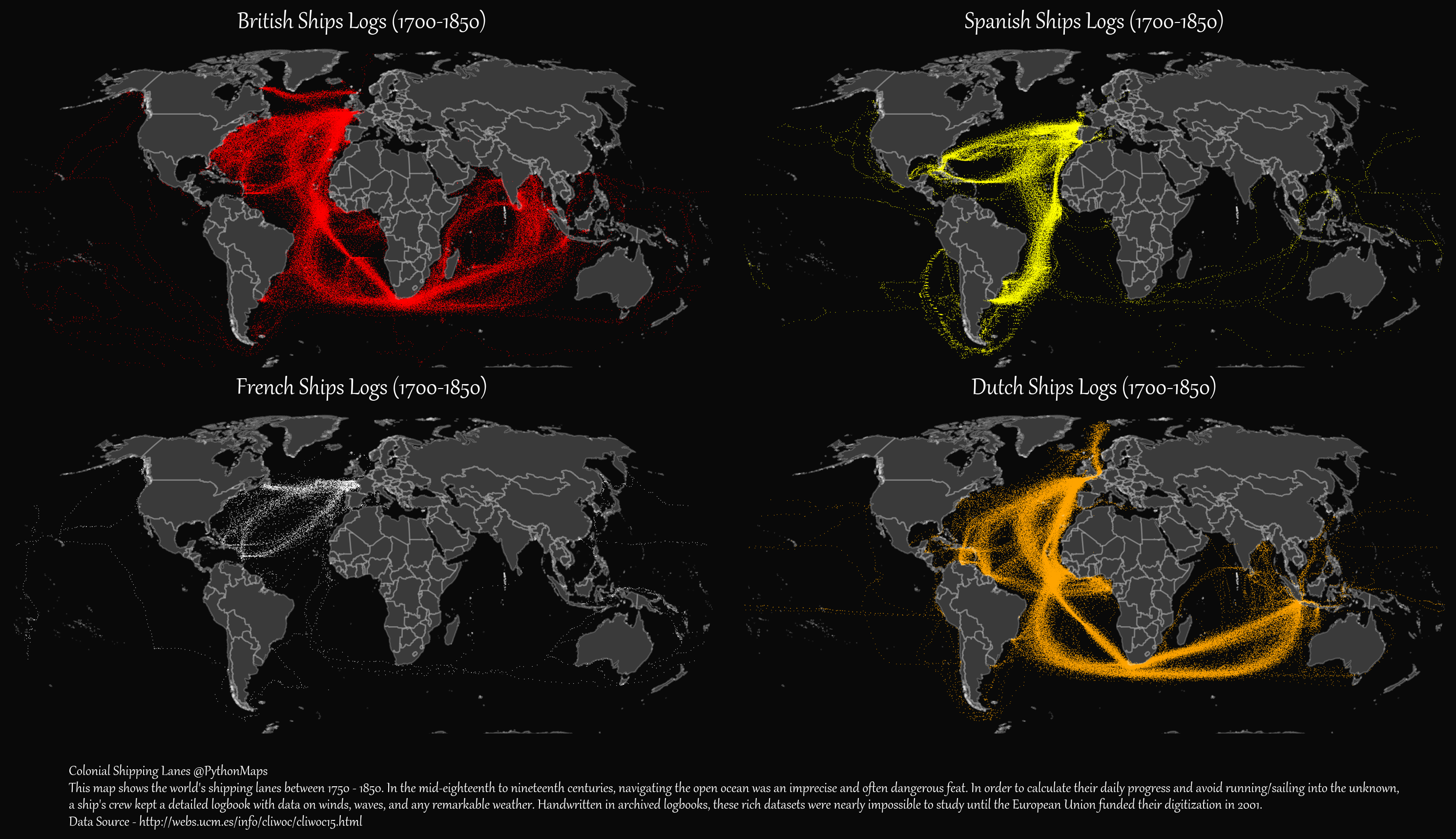
European Colonial Shipping Lanes (1700‒1850)
Every year, thousands of ships ferry passengers and transport goods across the world’s oceans and seas.
200 years ago, the ships navigating these waters looked very different. Explorers and traders sailed from coast to coast to expand colonial empires, find personal riches, or both.
Before modern technology simplified bookkeeping, many ships kept detailed logbooks to navigate, tracking the winds, waves, and any remarkable weather. Recently, these handwritten logbooks were fully digitized into the CLIWOC database as part of a UN-funded project by the University of Madrid.
In this graphic, Adam Symington uses this database to visualize the British, French, Spanish, and Dutch shipping routes between 1700 and 1850.
Colonial Shipping Lanes
In the 18th and 19th centuries, the British, French, Spanish, and Dutch empires dominated global trade through their colonial shipping lanes.
All four nations sailed across the Atlantic Ocean with some frequency over that timeframe, but these fleets were also very active in the Pacific and Indian Oceans as well.
The table below reflects the record of days spent by digitized logbooks from each nation.
| Country | N. Atlantic | S. Atlantic | Indian Ocean | Pacific | All Oceans |
|---|---|---|---|---|---|
| 🇪🇸 Spain | 28,635 | 11,812 | 620 | 1,703 | 42,770 |
| 🇬🇧 U.K. | 40,873 | 17,732 | 23,106 | 1,481 | 83,192 |
| 🇳🇱 Netherlands | 51,977 | 23,457 | 31,759 | 1,481 | 108,674 |
| 🇫🇷 France | 3,930 | 186 | 205 | 896 | 5,217 |
| Total | 125,415 | 53,187 | 55,690 | 5,561 | 239,853 |
Does this mean that the Netherlands had the widest colonial reach at the time? Not at all, as researchers noted that there were thousands of logbooks from each country that weren’t able to be digitized, and thousands more that were lost to time. The days simply reflect the amount of data that was available to examine from each country.
But they can still give us an accurate look at critical shipping routes between European countries, their trade partners, and their colonies and territories.
Let’s now take a closer look at the colonial powers and their preferred routes.
The British
The British shipping map shows a steady presence across the Atlantic and the Indian Ocean. They utilized many of Europe’s ports for ease of trade, with strong pre-independence connections to the U.S., Canada, and India.
One of the most frequented shipping routes on the map seen is a triangular trade route that enabled the trans-Atlantic slave trade. This route facilitated the transportation of slaves from Africa to the Americas, raw materials such as sugar, tobacco, and cotton from the American colonies to Europe, and arms, textiles, and wine from Europe to the colonies.
The Spanish
During this period, Spanish maritime trade with its colonies was an essential economic component of the Kingdom of Spain (as with other colonial empires).
We can see the largest concentration of Spanish ships around Central and South America leading up to the Spanish American wars of independence, as those colonies were especially important suppliers of raw materials such as gold, silver, sugar, tobacco, and cotton. There are some lanes visible to Pacific colonies like the Philippines.
The French
Of the four empires, France’s maritime logbooks were the most sparse. The records that were digitized show frequent travel and trade across the North Atlantic Ocean to Canada and the Caribbean.
The French empire at the time included colonies in the Caribbean, Indian Ocean, and West Africa. Their trade routes were used to transport goods like sugar, coffee, rum, and spices, while also relying on the slave trade to maintain plantation economies. The French colony of Saint-Domingue (now Haiti) was one of the world’s wealthiest colonies in the late 18th century.
The Dutch
Dutch shipping routes from the time had the most detail and breadth of any country, reflective of the Dutch East India Trading Company’s position as the world’s dominant company and trade force.
These include massive traffic to the Dutch East Indies (now Indonesia), Cape Colony (now South Africa), and the Guianas in South America.
Interestingly, researchers from Leiden University found that the Dutch empire was a “string of pearls” consisting mostly of strategic trading hubs stretched along the edges of the continents and focused on maritime power.